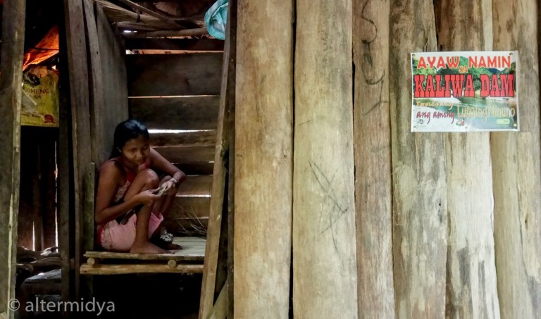
Angeline dela Karsada was crafting a pouch out of abaca when we arrived exhausted at her hut. Apologizing for the disturbance, we asked if we could use her bench to eat our very late lunch. The light was already slant and golden. On the doorpost, a small, rather faded “Ayaw Namin sa Kaliwa Dam” (No To Kaliwa Dam) banner was tacked next to a local politician’s shiny campaign poster.
It took a grueling four-hour trek to reach Sitio Quevorosa, a quiet riverside community of Dumagats in Brgy. Magsaysay, Infanta, Quezon, one of the villages affected by the government’s New Centennial Water Source Project (NCWSP). The NCSWP is the construction of three mega-dams (Kaliwa, Kanan and Laiban) at the Kaliwa-Kanan-Agos River Basin, which snakes through several municipalities in the provinces of Rizal and Quezon. To be funded through a controversially lopsided multi-billion peso loan under a contract with the Chinese government, the NCWSP is a priority project of the Duterte administration.
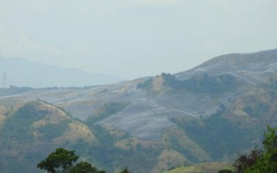
Sitio Quevorosa is Kaliwa Dam’s ground zero. On that small coconut grove inhabited by around 30 families, where the river bends and forks towards General Nakar, a concrete-faced rockfill dam will rise. A dam is always destined to be a monstrosity tens of meters high, made to abruptly and decisively stop the rush of water that for centuries had, like blood, flowed through particular veins of a particular heartland—in this case, the Sierra Madre mountain range.
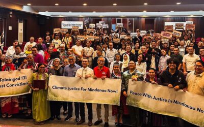
We had joined “Maki-Agos,” a solidarity trek with indigenous people organized for urban dwellers who want to see just exactly what it was that the government was pushing in our name. Many of us were coming from homes where faucets were dry at certain times of the day, endlessly annoying our lives. Yet all of us understood one way or another that a dam opposed by so many sectors cannot be the right solution to the so-called “water crisis.”
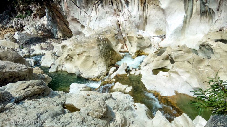
Our trek started from the camping grounds of Tinipak River, a tourist spot of modest fame. Here, vacationers were mostly content to dip and congregrate in its cool, deep pools, taking selfies atop distinctively white, irregularly shaped rocks. Turns out that the the haphazard scattering of these pretty rocks all across the river was no act of God. “A long time ago, those marble rocks were mined. But we took notice and stopped them,” our guide Freddie dela Cruz, a Dumagat chieftain, told me, in explanation of why the rocks jutted out like so many broken teeth. I pressed him for more but he repeated that it was a long time ago, when he was still in his teens, and he could no longer recall details of that foregone struggle.
A trip to Tinipak River and Cave is usually taken in combination with a hike to Mount Daraitan of neighbouring Tanay, Rizal. Around it, a community of tour guides, vendors, tricycle drivers and horse owners scramble to secure their means of livelihood. Tatay Freddie, for instance, also sells fresh coconut to visitors for 20 pesos apiece.
Even so, the Dumagat are mindful that Tinipak was once considered sacred ground by their ancestors. “Our parents used to bathe us in those waters when we were sick. They believed it had healing powers,” the chieftain said. And so a prominent sign disallowing bathing, doing laundry, or washing utensils in the riverbed. Camping was also prohibited in certain places.
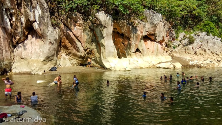
Environmentalists are convinced that the dam will inundate Tinipak and wipe out all tourism in the area. And while my stomach churned at the thought of Filipinos being robbed of a cheap vacation spot, I wasn’t fully understanding what inundation meant until the chieftain articulated a fear of how “big snakes inside the caves” might come out of hiding. Saving me from the idea of river monsters emerging from the deep, someone from the group helpfully explained how inside caves are actually water systems much like what we see aboveground—rivers, waterfalls and tributaries, all crucial in maintaining the watershed on high—such that flooding a cave complex would be like submerging a hidden village, all unique life, unseen activity, and nameless features erased.
At the beginning of our trek, Tatay Freddie pointed out a couple of cement markers that are supposedly for the road to be constructed for the dam. He had helped carry them, not really knowing what they were for. “They say that the huge trucks that will build the dam will pass through here,” he said.
On that day, though, the mountain was still quiet, languishing under the heat of the midday sun. Nothing or no one else was passing through except our group and several farmers on horseback. Dry branches scratched at our legs and feet. Finally, after an hour of trekking, we reached the banks of the river. It waters were emerald green and inviting.
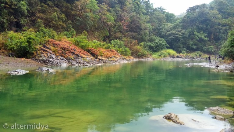
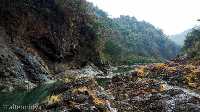
The Kaliwa River trek was not easy. Many times, we had to scramble over boulders, wade through waters swirling with thick moss, and inch our way through narrow banks. We crossed the river repeatedly, water reaching above our waists. But the difficulty of navigating the river on foot was related intimately to the pleasure of appreciating its magnificence. It was karst terrain, and so owed much of its beauty to limestone formations and excavations, on and around which foliage grew and the river mildly ran its course. The result of this congregation was a natural palette—yellow-orange shrubs grew prodigiously out of cracks in indigo slabs of rock; water flowed one moment aquamarine, the next a deep dark green; brick-red and moss green stones the size of melons were strewn across the greyish bank.
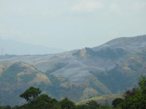
I later learned that the surrounding mountains form the Rizal-Infanta-General Nakar Natural Park, Wildlife Sanctuary and Game Preserve. Despite being a protected area, it had been heavily logged over the past decades, such that the western portion of the Kaliwa Low Watershed is considered deforested. The quality of the forests directly manifests itself on the quality of the river—degradation was why the river was already shallow in many parts, the big boulders that used to be underwater now exposed. Still, the eastern portion was covered in residual and old growth forest, and over-all, the Sierra Madre and the Kaliwa River retained their twin majesty. Twice, eagles circled us overhead. Small fish zigzagged through clear waters. Dragonflies and butterflies fluttered by.
Although it was then still the middle of summer, it started to rain. It was quite a downpour—perhaps it is because air that passes over forested land produces twice as much rain as that which passes over sparse vegetation (actually a fact that makes clearing the forest to build a dam for water supply a huge contradiction).
After more than a couple of hours of alternately being rained on and shone upon, it was a relief when we reached a hot spring. Feet terribly sore, many of us stopped to soak in bliss. There were parts where the water was hot enough to scald the skin. And, apparently, hot enough to melt the last of the glue that attached the sole of my right sandal. Shall I have to tread barefoot over many more miles? I nervously pondered, sole in hand.
Thankfully, Sitio Quevorosa did not lie far. It was a small village, only a cluster of houses could immediately be seen. All the adults chewed betel nut. The first Dumagat we met, Nanay Angeline, was unequivocal about her feelings towards the dam. “This isn’t really about us. It’s about the next generation. If in the beginning the dam is strong what happens when it disintegrates and breaks?” she said, in a few words of conversation betraying a survivalist acumen that struck me as both ancient and modern.
I learned from her that MWSS officials visited last April, confirming that they would have to leave once the dam construction starts. Leaving a place behind was nothing new for the Dumagats, who, like many indigenous peoples, were itinerants. In fact, they used to live higher up the mountains, but settled by the river because it was nearer the school—nearer being perhaps an hour’s trek instead of three. But for people who consider the entire Sierra Madre their home, it was clear that the impact of the dam would reach them wherever they go.
Besides, they were by their own standards settled quite nicely. Their coconut trees had taken eight years to become full grown. They planted rice, vegetables, and root crops; they fished in the river for food. “They want to relocate us to a grassland. But we already have a good life here. If they drown our crops then we would have to plant again, it would take a while before we can enjoy the fruits of our labor,” she explained.
They were wooed with promises of jobs and the construction of a road which, MWSS officials say, will make the market where they can buy food more accessible.” The idea sounded ridiculous to her. “What will we buy in the market if we don’t have any livelihood? Maybe there’ll be jobs while the dam is being constructed. But when it’s done? What jobs will they have for us? They wouldn’t even allow us to go into the forest, as security will be tight.” I remembered the apprehension of Tatay Freddie, who, on the other hand, was promised a job as a security guard. Perhaps here was the apocalyptic future of Dumagats envisioned by the government: keep one half starved; feed the other half to keep the starved half out of the forest.
Another Dumagat woman, Helen dela Cruz, was even promised a big house and a car that would “take them to the market in minutes.” I thought that whoever said that must have landed there on a helicopter or simply loved to exaggerate: no road, no matter how well-paved, could ever cover the distance we had just traveled in minutes. “I don’t really mind my small house,” Nanay Helen said, motioning to her shack. “And I don’t really mind walking for hours, as long as they don’t build the dam.”
The villagers’ ability to see through those individual bribes befits the scale of the struggle needed to stop the dam, whose impacts go far beyond their small community.
I later learned that the NCWSP is expected to submerge 113 hectares of protected land in Rizal, Infanta, and General Nakar. Inundation meant the loss of vegetation—simply put, plants would lose their ability to photosynthesize and so would disintegrate and rot. Philippine native trees like the white lauan, tanguile, bagtikan, guijo, rattan and bamboo would be affected. So too will the already vulnerable wildlife that rely on trees for habitat, such as the Philippine eagle, tariktik, bleeding heart pigeon, northern rufous hornbill, and the Philippine brown deer.
Aquatic species, too, will die off as a result of the reduction of water volume downstream. Decomposition of submerged vegetation will cause a decline in oxygen, affecting both commercially viable fish (tilapia, mudfish, eel, catfish) as well as some rare fish species found in the river. River sedimentation will also increase, damaging fish gills and disturbing feeding habits. Migratory fish species, which move from saltwater to freshwater, would also be doomed.
That wasn’t even the half of it, since it wasn’t just the inundated area that would be destroyed by the dams. In order to get the water to Metro Manila, conveyance tunnels would have to be built. Twenty-seven kilometers of tunnels, to be precise. Imagine the racket that blasting holes in the earth, roughly the distance from Fairview to Baclaran, would make throughout the Sierra Madre. Imagine the destruction that would be left in its wake, the number of farmers and indigenous peoples that would be displaced. Meanwhile, in downstream General Nakar, Quezon, it is estimated that 1,600 farmers would lose water for irrigation once the water has been dammed.
So while Sitio Quevorosa is ground zero, its fate is just the tip of the iceberg—the impacts of the Kaliwa Dam seem to be far greater than any one person can imagine, than any one journey can measure, than any one generation can suffer from.
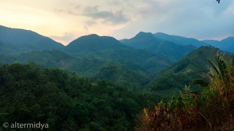
Since it would soon be nightfall and crossing the river on foot would now be dangerous, we were led onto a different route heading back to camp. It was a route that took us straight into the Sierra Madre. And while the trek was neither shorter nor less arduous, it had its perks as well: walking near the coolness of waterfalls, being sheltered under trees, encountering surprise vistas that took your breath away. We passed by several communities born from the mountain’s womb. At one point we descended down an extremely long flight of concrete stairs, it must have been hundreds of steps—how it was constructed in the middle of the forest, none of us knew (largely because none of us could see anything either, beyond the short path illuminated by our flashlights). But it was proof that these were communities with activity no less important, no less vibrant than those conceived in the heart of the metropolis.
So much more needs to be said about a dam not being the answer to Metro Manila’s water woes (there are in fact a whole different set of arguments that can prove just that). But what I learned from that trek is that there are worlds of wonder and worlds of woes that can exist without an ordinary city dweller ever knowing, much more government bureaucrats who can only understand profit and not the suffering it brings.